
Water Monitoring
The City of St. Albert monitors water quality at six different sites along the Sturgeon River four times per year: in the spring, after a summer rainfall, in the fall during low flow conditions and in the winter under the ice.
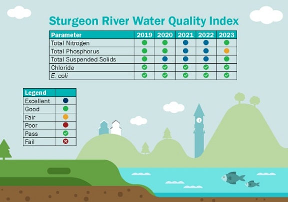
The City tests metals, bacteria, nutrients and salts and monitors pH levels, dissolved oxygen, and conductivity. Every two years, the City also measures pesticides. The results of these parameter tests are communicated through the water quality index below, which reports on the annual health of the river.
Parameters Indicating River Health
Total Phosphorus and Total Nitrogen | E. coli |
Chlorides | Total Suspended Solids |
Total phosphorus, nitrogen and suspended solids (nutrients)are compared to historical levels as per the provincial guidelines.Levels of chloride andE. coliare measured against existing provincial environmental guidelines. This is where the Sturgeon River (within the City of St. Albert boundaries)has landed on the index:
Water in the storm drains does not receive any chemical pre-treatment, it may flow through an oil and grit separator to remove solids and oils, but then flows directly into the river. Therefore, the activities we perform on the landscape can have a large effect on the water quality in the river.
The Sturgeon River has not experienced drastic changes to the background nutrient levels and chloride andE. colihaveconsistently been within the provincial guidelines. Contaminant levels vary based on precipitation amounts, evaporation rates and vegetation conditions on the landscape.
How Are Results Used?
The results are used to inform best management practice improvements for utilities operations such as the installation of oil and grit interceptors to decrease sediment inputs to the river from stormwater outfalls. Results can also be used to highlight potential issues in the stormwater management facility systems and can result in changes in pesticide and salt use by City staff.
The data is used in regional collaboration efforts with the Sturgeon River Watershed Alliance, and Alberta Environment and Protected Areas. Annually, the City releases a Report on the Environment, in which there is a river health index providing a snapshot of the river’s condition over the past year.
Sturgeon River Watershed Report
A State of the Watershed report was published in 2012 that summarizes the current knowledge of the Sturgeon River Watershed and its environmental integrity.
Learn more and view the reportRelated Pages


Last edited: November 6, 2024